 Firstlogic Team
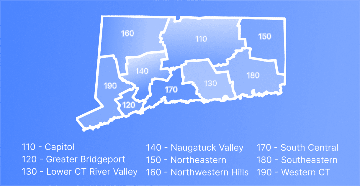
Connecticut’s nine planning regions are now recognized by the Census Bureau as county equivalents for statistical and geospatial products. This change replaced the state’s eight legacy counties beginning in 2022-2023 Census releases and now appears in TIGER/Line, ACS, and other federal datasets.
What Changed and When
- Decision: On June 6, 2022, the Census Bureau designated Connecticut’s nine planning regions as county equivalents, replacing the state’s eight historical counties.
- Codes: The old INCITS (FIPS) codes 09001-09015 were retired. The new county-equivalent codes range from 09110 to 09190.
- Data products: The change first appeared in 2022 TIGER/Line boundaries, 2022 ACS releases (published in 2023), and BLS CEW data for 2024.
- Continuity: Planning regions group towns differently than the old counties, so data cannot be joined directly between the two systems without town-level matching.
Old vs. New: Names and Codes
The following tables show the traditional Connecticut counties and the newer planning regions, along with their FIPS codes.
Important: Connecticut’s new planning regions do not line up exactly with the old counties. Each region is made up of a group of towns, and some of those towns used to belong to different counties. For example, the Naugatuck Valley Planning Region includes towns that were once part of both New Haven County and Litchfield County. This means you cannot directly match an old county name to a new planning region name. If you are comparing older county-based data to newer planning-region data, align your records by town first, then group them under the correct planning region.
Legacy counties
| County Name | State + County Code (FIPS) |
|---|---|
| Fairfield County | 09001 |
| Hartford County | 09003 |
| Litchfield County | 09005 |
| Middlesex County | 09007 |
| New Haven County | 09009 |
| New London County | 09011 |
| Tolland County | 09013 |
| Windham County | 09015 |
Current county equivalents (planning regions)
| Planning Region | State + Region Code (FIPS) | GNIS ID |
|---|---|---|
| Capitol Planning Region | 09110 | 02830244 |
| Greater Bridgeport Planning Region | 09120 | 02830245 |
| Lower Connecticut River Valley Planning Region | 09130 | 02830246 |
| Naugatuck Valley Planning Region | 09140 | 02830249 |
| Northeastern Connecticut Planning Region | 09150 | 02830250 |
| Northwest Hills Planning Region | 09160 | 02830251 |
| South Central Connecticut Planning Region | 09170 | 02830252 |
| Southeastern Connecticut Planning Region | 09180 | 02830253 |
| Western Connecticut Planning Region | 09190 | 02830254 |
Practical Implications for Data and Software Teams
In practice, this change means that all new federal and state datasets for Connecticut will reference the nine planning regions instead of the eight historical counties. Data systems that store or process county-level information should retain legacy county codes for backward compatibility but treat the planning region codes as current and authoritative going forward. When normalizing addresses or joining Census data, use the town-to-planning-region relationship to ensure accurate results. GIS layers, boundary datasets, and reference tables should be updated to TIGER/Line 2022 or newer.
FAQs: Connecticut County Equivalent Changes
When did the change take effect?
The Census Bureau officially adopted the nine planning regions as county equivalents on June 6, 2022. TIGER/Line and ACS began using the new geography with the 2022 data year.
How can I compare old and new datasets?
Connecticut’s planning regions do not match the old counties directly. To compare data across time, assign each town to its planning region and use that as the link between older county-based data and newer region-based data.
What happened to the old FIPS codes?
The legacy county FIPS codes (09001 through 09015) were retired when the Census Bureau adopted the nine planning regions as county equivalents. Historical datasets that use those codes are still valid for pre-2022 data, but new federal datasets now use the updated codes for planning regions.
What are the FIPS codes for Connecticut’s county equivalents (planning regions)?
The new codes use the standard Connecticut state prefix 09 followed by the three-digit region identifier.
The complete list is:
| Planning Region | FIPS Code |
|---|---|
| Capitol Planning Region | 09110 |
| Greater Bridgeport Planning Region | 09120 |
| Lower Connecticut River Valley Planning Region | 09130 |
| Naugatuck Valley Planning Region | 09140 |
| Northeastern Connecticut Planning Region | 09150 |
| Northwest Hills Planning Region | 09160 |
| South Central Connecticut Planning Region | 09170 |
| Southeastern Connecticut Planning Region | 09180 |
| Western Connecticut Planning Region | 09190 |
Sources
Sources: US Census Bureau (Federal Register Notice, June 6, 2022), Connecticut Office of Policy and Management, and USPS Publication 28.

Secondary Address Unit Designators – Official List and FAQs
In U.S. addresses, elements like “Apartment” or “Suite” are referred to as secondary address unit designators. Here we provide a list of these designators and their official USPS abbreviations.
A Business Guide to GIS Data Management
Introduction Geographic Information Systems (GIS) have moved from niche mapping tools to core infrastructure that supports strategy, operations, risk management, marketing and site planning. As organizations collect more location data from field workers, IoT sensors, mobile apps and external providers, the way they manage GIS data often becomes a limiting factor. Poorly managed spatial data […]